Why Vietnamese Travelers Call Que Phong The Da Lat Of Nghe An
Why Vietnamese Travelers Call Que Phong The Da Lat Of Nghe An
There are places in Vietnam that become famous because they are easy to sell in photographs. Then there are places like Que Phong, where the landscape unfolds slowly, one mountain curve at a time, until you suddenly realize you have stopped checking your phone for hours.
Located in western Nghe An Province near the Laos border, Que Phong is often described by domestic travelers as “The Da Lat of Nghe An.” At first, the comparison sounds exaggerated. There are no French villas hidden in pine forests. No cafés filled with tourists wearing wool sweaters. No polished tourism district carefully staged for social media.
And yet, after a few hours on the winding roads leading into the district, the comparison begins to make sense.
The cool mountain air.
The layers of mist drifting across valleys.
The enormous reservoir reflecting forests and clouds.
The feeling of distance from modern urban Vietnam.
Que Phong is not trying to entertain you. That is exactly why many travelers remember it long after they leave.
The district sits at a geographical crossroads between Nghe An, Thanh Hoa, and the mountain ranges stretching toward Laos. The region remains one of the poorest mountainous districts in Vietnam, but from a travel perspective, that isolation has preserved something increasingly rare in Southeast Asia: scale, silence, and cultural continuity.
The Road Into Que Phong Is Part Of The Experience
Many travelers underestimate how dramatic the approach to Que Phong can be. The roads twist through mountain passes with continuous hairpin bends. One turn reveals steep jungle slopes. The next opens into terraced rice valleys glowing yellow during harvest season.
A Vietnamese motorbike traveler once described the road this way in a local riding group:
“You never fully relax because every corner changes the landscape again.”
That description feels accurate.
Unlike heavily commercialized mountain destinations, the roads here still feel connected to local life rather than tourism infrastructure. Trucks carrying timber, women transporting vegetables, children cycling home from school, and water buffalo crossing narrow roads are all part of the journey.
The scenery becomes even more cinematic in late afternoon when sunlight cuts through the valleys and reflects against the Chu River.
From the outer districts of Que Phong, wide rice fields stretch alongside the calm riverbanks. Large bamboo water wheels rotate slowly beside the water, carrying river water into the fields exactly as they have for generations. White birds circle above the paddies. Smoke rises from village kitchens near sunset.
It does not feel curated. That matters.
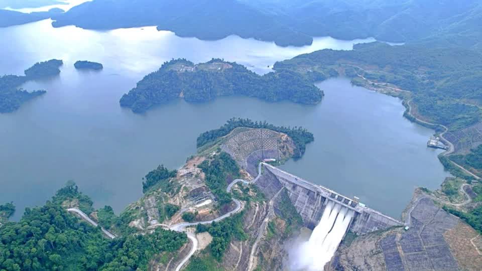
Hua Na Lake... The Landscape That Changed Everything
The emotional center of Que Phong today is Hua Na Hydropower Lake.
The reservoir extends across Dong Van and Phong Thu communes in a long S-shaped formation surrounded by mountains and protected forest. Although it was created through hydropower development, the lake still retains an unexpectedly wild atmosphere because many sections remain lightly populated and difficult to access.
In the early morning, fog drifts low across the water while tree-covered hills appear like floating islands. By midday, the lake changes completely. The water reflects strong sunlight and turns metallic blue-green under clear skies.
Some Vietnamese travelers compare parts of the scenery to northern Laos more than Vietnam.
The contrast between engineered infrastructure and untouched nature creates a strange visual tension. Fishing boats move quietly through drowned forests where treetops still emerge from the surface. Local Thai ethnic communities continue adapting their livelihoods around the changing environment.
One resident from Nam Khe resettlement village explained that many families now rely partly on fishing:
“The lake gave people another way to live. Some families catch dozens of kilograms of fish every day.”
Freshwater fish from Hua Na are well known locally, especially white mullet and stream fish species with firm meat and clean flavor. Meals in Que Phong are deeply connected to the forest and water systems around the district. Bamboo shoots, mountain herbs, grilled fish, sticky rice, and forest vegetables dominate local cooking.
The food here is not restaurant-oriented cuisine. It is seasonal, practical, and local.
Sao Va Waterfall Feels Larger Than Photographs Suggest
Around 20 kilometers from Que Phong district lies Sao Va Waterfall, one of the most visually dramatic natural sites in western Nghe An.
The waterfall spreads more than 100 meters across a valley and crashes into a deep basin below. According to Thai ethnic folklore, the waterfall was once a bathing place for daughters of the Water King descending from heaven.
Local legends say unmarried young men should not swim beneath the falls or the spirits might take them away.
Stories like this remain important here. In Que Phong, mythology is not packaged as entertainment. It still exists naturally inside daily conversation.
The basin beneath Sao Va appears calm from a distance, but locals describe it as dangerously deep, especially during rainy season when upstream floods carry rocks and debris into the valley.
Travelers visiting during heavy rain periods should be cautious. This is not a managed waterfall park with railings and tourist cafés everywhere. Conditions can shift quickly.
And that is partly why the experience still feels authentic.
Things The Media Doesn't Tell You
Most travel coverage about Que Phong focuses on “untouched beauty” and ethnic culture. That language is easy to write. Reality is more complicated — and more interesting.
Infrastructure Is Still Developing
Road conditions can vary dramatically depending on weather. Fog reduces visibility quickly in mountain sections. Some routes become difficult after heavy rain, especially for inexperienced motorbike riders.
If you are planning independently, research recent road conditions through local Facebook travel groups, Vietnamese rider forums, Google Maps reviews, and recent YouTube or TikTok travel videos. Conditions change seasonally.
Tourism Services Remain Limited
This is not Sa Pa or Da Lat.
English-speaking services are limited outside basic accommodations. ATMs are not always reliable in remote areas. Travelers expecting polished hospitality may struggle here.
But travelers looking for slower interaction often appreciate exactly that lack of commercialization.
Hydropower Changed The Region
Hua Na Lake is visually stunning, but it also reshaped local communities through relocation and environmental change. Some villages benefited economically. Others lost agricultural land and traditional settlement areas.
A planner looking seriously at Que Phong should acknowledge both sides of that transformation rather than reducing the lake to a scenic viewpoint.
Weather Shapes Everything
Que Phong changes dramatically by season.
Dry months reveal rice valleys and clearer roads. Rainy months create stronger waterfalls and thicker fog, but also increase landslide risks and transport delays.
A local guide once summarized the region perfectly:
“You don’t visit Que Phong to control the experience. You visit to move with the mountain.”
Thai Ethnic Hospitality Still Defines The Region
The Thai ethnic communities in Que Phong remain central to the district’s identity. Hospitality here is not performed as a tourism product in the same way seen in some commercialized mountain destinations.
Guests are often offered the best blanket, the warmest sleeping space, or the first serving of sticky rice wine during meals. These traditions continue because they are socially important, not because they generate online reviews.
That distinction becomes noticeable quickly.
In some villages near Hua Na, evenings remain remarkably quiet. You hear insects, distant dogs, water movement, and occasional conversation from wooden stilt houses. For travelers used to urban Vietnam, the silence itself can feel unfamiliar.
The Curious Mystery Of The Lake Forests
One of the strangest visual details around Hua Na is the partially submerged forest landscape. Trees still rise from the water surface in certain sections, creating an eerie atmosphere at sunrise and sunset.
Fishing communities move quietly between these drowned forest zones, where fish populations gather beneath the branches.
The result feels cinematic without trying to be cinematic.
Several Vietnamese photographers describe Hua Na as one of the few reservoirs in the country where the surrounding forest still visually dominates the engineered structure itself.
A Place That Rewards Slow Travel
Que Phong does not offer a checklist experience.
There are no giant entertainment complexes. Few luxury resorts. Limited nightlife. Sparse transportation schedules. Weak mobile signals in some valleys.
But for travelers willing to slow down, the district offers something increasingly difficult to find in Asia’s fast-growing tourism economy: a landscape still moving at local speed.
Morning markets open quietly. Fishermen return before sunrise. Rice fields shift color with weather and season. Fog arrives without warning. Conversations happen slowly over rice wine and grilled fish.
And perhaps that is why the comparison to Da Lat continues to survive among Vietnamese travelers.
Not because the places look similar.
But because both destinations create the same rare sensation — the feeling of temporarily stepping outside the rhythm of ordinary life.
Inside Hua Na - Fishing Villages Forest Lakes And A Different Side Of Nghe An.
Que Phong travel, Hua Na Lake, Sao Va waterfall, Nghe An mountains, western Nghe An, Thai ethnic villages, Vietnam mountain travel, Hua Na reservoir, Que Phong guide, Nghe An nature, Vietnam waterfalls, remote Vietnam, Vietnam road trip, Chu River valley, northern Vietnam scenery
